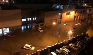
Wild weather caused flash flooding in Hobart on Friday morning, with cars swept away and emergency crews responding to hundreds of calls for help.
Police said the city centre was hit hard, forcing the closure of many roads and, with more heavy rain expected on Friday, motorists were urged to stay off roads.
Streets turned into fast-flowing rivers, with water surging inside homes and businesses. Two evacuation centres were set up as State Emergency Service crews worked to prioritise hundreds of calls for assistance.
Flash flooding also hit the suburbs of Blackmans Bay, Sandy Bay and Kingston on the city’s outskirts. The University of Tasmania’s Sandy Bay campus was closed after some buildings flooded and power was cut.
“Staff and student safety is our priority and access will not be restored to the campus until appropriate checks are made,” the university said on its website.
Education officials closed 19 schools and more than 13,000 properties lost power as the storms rolled in, while some vehicles were swept away after Hobart received almost 130mm of rain in 24 hours.
“When we came down here I didn’t even see my car,” one woman told the Seven Network. “I thought someone might have stolen it.”
Emergency services have received hundreds of calls for assistance, including for wind damage to roofs and sheds and trees blown over, but there were no immediate reports of injuries, police said on Friday.
People were urged to avoid non-essential travel in storm-hit areas, especially the central business district.
“Major roads in the CBD are significantly affected by flood waters and debris, and power outages are affecting some traffic lights,” police said.
Emergency crews were mobilised to clear the roads, but many were likely to remain closed during the morning’s peak hour.
Vica Bayley reported on Twitter that a fish farm had washed up on Hinsby Beach, south of the Hobart CBD.
The intense low pressure system responsible for the wild weather would continue until the afternoon, the Bureau of Meteorology warned.
“Rainfall is locally heavy about the eastern, southern, and central areas this morning, things will ease this afternoon and then contract to the north-east tonight,” a bureau forecaster, Debbie Tabor, told the Mercury.
“We’ll still have some showers left around, but the heaviest falls are likely to be this morning in the south and then along the east coast in the afternoon.
“There is the possibility of thunderstorms in the south and the east also.”
The complex low-pressure system that caused the Tasmanian floods also led to cold snaps other parts of the south east of the country, with residents in New South Wales waking up to a blanket of snow. The Bureau of Meteorology reported that the Central Tablelands received a dusting overnight, with a few centimetres falling on higher peaks.
Residents in Oberon and Blayney have posted photos to social media of a whiteout over the countryside, while motorists have been warned to take extra care on the roads and to drive to the conditions.
The weather bureau issued a sheep graziers warning for parts of inland NSW for cold temperatures, rain and showers and westerly winds. Damaging winds are also expected along the state’s southern coastline, with surfers, boaters and rock fishers warned of hazardous surf conditions.
source: the guardian

