logo2

ugm-logo

Blog

FEMA opens Disaster Recovery Center in Utica in response to February flooding

UTICA, Ind. (WDRB) – Now that federal disaster aid has been approved for some southern Indiana counties, residents are looking at their next step.

On Sunday, FEMA opened its Disaster Recovery Center (DRC) on North Fourth Street in Utica to help the more than 100 residents and businesses affected by February’s flooding.

Inside, a dozen volunteers waited to assist residents who need an extra boost getting on their feet with the help of counselors.

After receiving a request from the state, President Trump ordered the federal assistance earlier this month for several Indiana counties including Clark, Floyd, Harrison, and Jefferson.

Residents wish the aid was quicker - but know a lot of red tape needs to be cleared to make that a reality.

“If you are older, I am too, and you’re not working you got a burden on trying to replenish from a flood and it’s that important to have it here,” said Utica Town Board President Steve Long.

Once insurance and FEMA assistance is exhausted, residents are encouraged to apply for a SBA – or a Small Business association loan - to help with payments which can be much more cost efficient than putting damages on credit cards.

“Credit card interest is 13, 14, 15 percent. We have a program available through the SBA that is only 1.8 percent, and they will spread it out over a longer period of time,” said FEMA Media specialist Troy York.

The FEMA registration process is often the first step in recovery and requires information such as insurance policies and bank information for possible direct transfer of funds. Survivors are encouraged to register with FEMA before visiting a DRC.

“These people here are struggling,” said Long. “They are proud people and they are going to come back and that’s a positive sign, it really is.”

FEMA Disaster Recovery Center

Utica Town Hall

107 N. 4th Street

Utica, IN 47130

Hours: 9 A.M. – 7 P.M. Seven days a week

For information and how to register head to: https://www.fema.gov/disaster/4363

Those looking for Federal Aid for flood recovery have until July 4th to apply.

Copyright 2018 WDRB Media. All Rights Reserved.

Flash flooding hits Hobart after torrential rain, snow falls in NSW

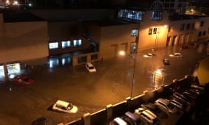
Flash flooding in Hobart washed up a several cars on Macquarie Street in the city.

Wild weather caused flash flooding in Hobart on Friday morning, with cars swept away and emergency crews responding to hundreds of calls for help.

Police said the city centre was hit hard, forcing the closure of many roads and, with more heavy rain expected on Friday, motorists were urged to stay off roads.

Streets turned into fast-flowing rivers, with water surging inside homes and businesses. Two evacuation centres were set up as State Emergency Service crews worked to prioritise hundreds of calls for assistance.

Flash flooding also hit the suburbs of Blackmans Bay, Sandy Bay and Kingston on the city’s outskirts. The University of Tasmania’s Sandy Bay campus was closed after some buildings flooded and power was cut.

“Staff and student safety is our priority and access will not be restored to the campus until appropriate checks are made,” the university said on its website.

Education officials closed 19 schools and more than 13,000 properties lost power as the storms rolled in, while some vehicles were swept away after Hobart received almost 130mm of rain in 24 hours.

“When we came down here I didn’t even see my car,” one woman told the Seven Network. “I thought someone might have stolen it.”

Emergency services have received hundreds of calls for assistance, including for wind damage to roofs and sheds and trees blown over, but there were no immediate reports of injuries, police said on Friday.

People were urged to avoid non-essential travel in storm-hit areas, especially the central business district.

“Major roads in the CBD are significantly affected by flood waters and debris, and power outages are affecting some traffic lights,” police said.

Emergency crews were mobilised to clear the roads, but many were likely to remain closed during the morning’s peak hour.

Vica Bayley reported on Twitter that a fish farm had washed up on Hinsby Beach, south of the Hobart CBD.

The intense low pressure system responsible for the wild weather would continue until the afternoon, the Bureau of Meteorology warned.

“Rainfall is locally heavy about the eastern, southern, and central areas this morning, things will ease this afternoon and then contract to the north-east tonight,” a bureau forecaster, Debbie Tabor, told the Mercury.

“We’ll still have some showers left around, but the heaviest falls are likely to be this morning in the south and then along the east coast in the afternoon.

“There is the possibility of thunderstorms in the south and the east also.”

The complex low-pressure system that caused the Tasmanian floods also led to cold snaps other parts of the south east of the country, with residents in New South Wales waking up to a blanket of snow. The Bureau of Meteorology reported that the Central Tablelands received a dusting overnight, with a few centimetres falling on higher peaks.

Residents in Oberon and Blayney have posted photos to social media of a whiteout over the countryside, while motorists have been warned to take extra care on the roads and to drive to the conditions.

The weather bureau issued a sheep graziers warning for parts of inland NSW for cold temperatures, rain and showers and westerly winds. Damaging winds are also expected along the state’s southern coastline, with surfers, boaters and rock fishers warned of hazardous surf conditions.

source: the guardian

Flood and wildfire review calls for better communication with First Nations

An independent review into last year's devastating wildfires and floods in B.C. has found better communication and coordination is needed with First Nations communities.

The report makes more than 100 recommendations on how the B.C government can improve its response to natural disasters.

Many of the recommendations address issues such as the need to include Indigenous communities as true partners during planning and decision making.

"We are not just a community or a stakeholder. We are governments equal to local, provincial and federal governments," said report co-author Chief Maureen Chapman of the Skawahlook First Nation.

"Making those alliances across whatever boundaries people create, whether it is municipalities or cities or reserve lines, is something that needs to  be set aside."

The report also calls on governments to build cultural sensitivity training and awareness of racism and discrimination into emergency management plans and to encourage the integration of traditional knowledge.

Better preparation

The report also notes there is a growing gap between the amount of money the province spends on responding to disasters and the funds available for prevention.

A multi-year prevention strategy is needed, said report co-author George Abbott, a former Liberal MLA.

"I salute what government has done and what government is doing, but we have, I think, given the magnitude of the challenge a significantly long way to go yet," he said.

Some of the other 108 recommendations include:

  • a re-evaluation of all 200-year return-period flood elevations
  • steps to reduce the vulnerability of structures to fires
  • establish centres of excellence in interior locations to support large-scale disaster response
  • build a 'one-stop-shop' emergency communications website
  • mandate the insurance industry to create an incentive program to encourage a proactive approach to emergency preparedness

Provincial officials say there is no estimate on what it would cost to implement all 108 recommendations in the report.

But 19 of the recommendations have been addressed based on internal reviews by ministries into last summer's wildfire and flood response, said Forests, Lands and Natural Resources Minister Doug Donaldson.
 

A record-breaking season

The province spent $550 million fighting the wildfires, which displaced 65,000 people and destroyed 1.2 million hectares of forest.

No lives were lost, but some residents questioned whether officials did enough to save homes.

The review was conducted by George Abbott, a former B.C. Liberal MLA and Maureen Chapman, a hereditary chief of the Skawahlook First Nation.

They held community consultations and toured damaged areas of the province. 

The remains of mobile homes destroyed by wildfire in Boston Flats as a fire burned on a mountain east of Cache Creek, B.C., on Sunday July 9, 2017. (Darryl Dyck/Canadian Press)

Independent review necessary

Individual government ministries also conducted their own reviews.

But an independent report was called for because of the severity of the situation, said Doug Donaldson, the minister of Forests, Lands and Natural Resources.

"We had internal reports done about how the government responded to these situations and we just felt with the scope and scale of what was experienced that an independent report was justified as well," he said.

The 2017 fires were preceeded by severe flooding in the B.C. Interior. Communities such as Cache Creek, Kelowna, Vernon and Dawson Creek were hit hard.

The fires and floods combined resulted in the largest claim in history — estimated at $400 million — under Canada's Disaster Financial Assistance Arrangements.

An RCMP officer stands on the road in the Williams Lake area. The entire city was placed under an evacuation alert during the 2017 wildfires. (CBC)

Disaster Preparedness for Those w/Special Needs

While most disasters can’t be prevented, the stress of such situations can be reduced significantly through personal preparedness. This is particularly important for households with members who have disabilities, functional needs or may need assistance during an emergency.

Throughout May, the Illinois Emergency Management Agency (IEMA) and local emergency management agencies will highlight the importance of disaster preparedness for people with functional and access needs.

“Disasters can cause power outages, force people to evacuate their homes or create other dangerous situations,” said IEMA Acting Director William P. Robertson. “We encourage everyone to be prepared, especially those who may have medical, functional or access needs.”

Robertson said IEMA has information available on the Ready Illinois website (www.Ready.Illinois.gov) to help people and caregivers prepare for emergencies. A guidebook, Emergency Preparedness Tips for Those with Functional Needs, offers preparedness tips for people with visual, cognitive or mobility impairments, people who are deaf or hard of hearing, those who utilize service animals or life support systems, and senior citizens.

For each functional need, the guidebook provides a list of supplemental items for a disaster kit, tips on developing an emergency plan, suggestions on how to be better informed about community emergency planning, and a checklist of preparedness activities.

The Ready Illinois website also offers more than two dozen preparedness videos in American Sign Language on such topics as what to do before, during and after tornadoes, severe thunderstorms and flooding, how to build an emergency supply kit, and what to do if you’re instructed to evacuate.

Hawaii volcano: Aerial views show slow-moving disaster unfolding as lava envelops homes

A volcanic eruption on Hawaii's Big Island intensified over the weekend, with some people potentially stranded in their homes.  The eruption of Kilauea Volcano on Hawaii's Big Island has spewed vast amounts of lava for more than three days and nights.

Hundreds of earthquakes have also rocked the area, and more volcanic cracks opened in the ground over the weekend. At least 31 homes and other structures have been destroyed.

About 1,700 people living nearby have been evacuated.

Authorities have locked down the Leilani Estates neighborhood in Pahoa, more than 25 miles from the Kilauea Volcano. No residents are going in right now.

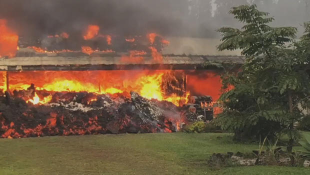
hawaii-volcano-home-destroyed-620.jpg

At least 31 homes and structures have been destroyed.

CBS News

Emergency management sent out a cellphone alert late last night, warning everyone who was still in the neighborhood to get out. But CBS News has learned there are still some people inside, and police say they're not going in to get them.

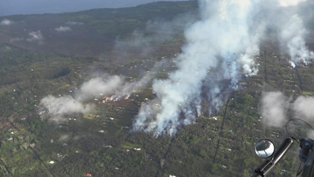
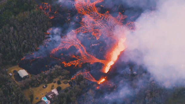
Correspondent Carter Evans got a view of the area flying overhead. From the air, lines of smoke show where lava is flowing through the Leilani Estates as homes continue to burn.

hawaii-volcano-aerial-view-620.jpg

An aerial view of fissures in the Leilani Estates neighborhood on Hawaii's Big Island.

CBS News

There are no firefighters down there, says Evans, because there's nothing they can do.

This is an unstoppable force.

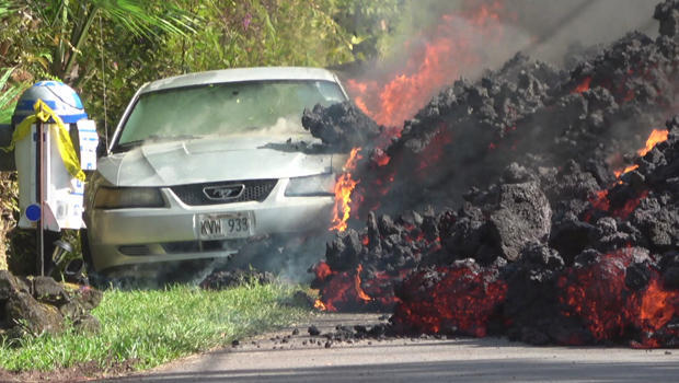
The slow-moving lava has consumed everything in its path, including trees and homes. Even a car was no match for the molten wall.

hawaii-volcano-lava-flow-torches-car-620.jpg

A car is torched by a slow-moving wall of lava.

CBS News

"The eruption progressed a few more extensive flows," said civil defense administrator Talmadge Magno. "It seems like there's a lot of magma underground, and there's no sign of [it] slowing down."

At least 10 fissures have opened up in Leilani Estates. In some cases the eruptions were so violent, lava spewed more than 200 feet in the air.

hawaii-volcano-fissue-aerial-view-paradise-helicopters-620.jpg

An aerial view of a fissure spewing lava at Leilani Estates.

Paradise Helicopters

On Sunday some evacuees were allowed back home to grab essentials. A line of cars waiting to return stretched more than two miles long.

How a Hawaii crater collapse led to latest volcanic eruption

"We choose to live here, but at the same time, yeah, it's painful, no question," said evacuee Lori Wada.

Evans asked, "Do you have any idea when you'll be able to go home again?"

"We don't even know if our home's going to be there again," she replied.

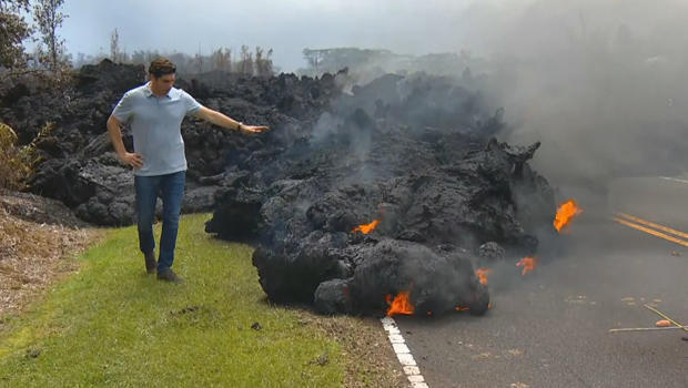
At first glance, it may not look like the mass of lava covering the roadway is moving at all. It's cooled, and there's a crust on top, but if you look at the leading edge, it is slowly inching forward.

hawaii-volcano-carter-evans-with-lava-flow-620.jpg

Correspondent Carter Evans with a lava flow at Leilani Estates.

CBS News

Over the weekend, the Big Island was rocked by hundreds of earthquakes, including one measuring magnitude 6.9 -- Hawaii's largest in more than 40 years.

Sam Knox lives about a hundred yards away from one of the eruptions. "It's like a Goliath, like a roaring jet engine," he said.

When asked why he chose to stay, Knox replied, "Because this is where I live, right here. I had faith in the gods that my house is going to be OK."

The lava is showing no signs of slowing down -- and that's just one of the concerns here. Another is the toxic smoke. The lava emits sulfur dioxide, which can be deadly. Authorities say levels of the gas in what they call the "hot zone" are extremely high.